Appreciation of the Chaco road system has been fairly recent. When I first visited the canyon in the 1950's there was no identification of the roads in the Park's information or designation of sites. Now one of the roads with stone stairway is included.
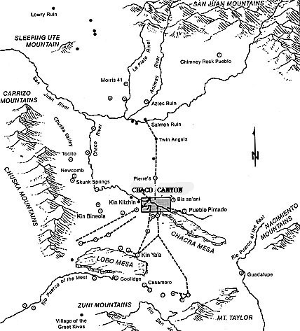
In the period fom 900 to 1200 AD outliers spread over
the San Juan River region of southern Colorado,northern New Mexico, down
to Zuni and east to near Albuquerque. Many of these villages (pueblos)
were connected by hundreds of miles of roads. For example some thirty outlying
pueblos have been found linked by one of six major road systems of at least
twenty miles in length. Early tales by Navajos and Mormon settlers suggested
these roads extended even further into present day Utah. The accompanying
map gives some idea of various main roads in western New Mexico.
Suggestions of their use for trade, ceremony, and distribution of crops within the precarious environment, pale in the face of the monumental nature of their construction. If today these roads are barely distinguishable from the ground in most places, requiring aerial photographs and these only enhanced by early or late day shading, still evidence reveals the roads were from 20 to 40 feet wide and were often terraced with stone and fill. They were also straight as an arrow and crossed mesas with stairs carved in the stone.
These were people on foot, using digging sticks, having no horses or wheeled vehicles. What could have inspired such effort and principle? Like the Roman soldiers of old who built fabulous roads still in use in order to maintain discipline among themselves and for support of the empire, these people must have been inspired by some higher nonutilitarian motive.
Being a highly religious people, I suggest the construction
process itself may have actually been a religious practice, an act of piety.
Each stone carried, each scoop of dirt, every carved step served as a prayer
to connect the harsh physical world to the animistic spirit realm. The
communication with the ceremonial center at Chaco Canyon suggests this
to me. Unlike our modern roads which began by following game trails,i.e.,
the easiest, most gradual route, these roads were conceived by a different
mentality, one seeing spirit in each material event and working to maintain
balance or influence with these events.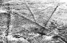
The photo at right shows the roads today, from the air. The dark shadows to the left of the white lines superimposed track the early route.
In the early 1990's Winston Hurst, archeologist and former curator of the Edge of Cedars Museum in Blanding Utah, decided to survey a stretch of road through Combs wash,Utah. He had observed some Chaco style building construction in the area, had taken aerial photos and published information on the roads, and was kin to early settlers who explored them. Several of us spent a week walking, collecting shards, and measuring features connected to the road. Page two shows pictures of our endeavors.
sources: Noble,NEW LIGHT ON CHACO CANYON(School of American Research)1984;Kinkaid,CHACO ROADS PROJECT:Phase I(BLM)1983;Hurst,Davidson and Severance,"Anasazi Roads in Southeastern Utah",Canyon Legacy,1990