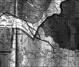
Map of trail to Truchas peaks from Rancho Arriba
This partial map of the Carson National Forest (available at forest service offices) shows the road from Rancho Arriba (at left) which becomes a foot trail (as it leaves the white area) to the Truchas peaks. Also visible (above) are the trails to the San Leanardo Lakes and the Trampas trail. Greater detail is shown on the U.S.G.S topo maps Truchas Quadrangle,El Valle Quadrangle, and Truchas Peaks Quadrangle